Smart Snap tool

Used to select key points such as the lowest, highest, average or median point along a user defined path. For example, find the peak line along a road centerline.
This utility works in conjunction with AccuSnap and uses the point found by AccuSnap as the center of the search area. The search area is a cylinder defined by three parameters : its center (i.e. where AccuSnap snaps), its height and its radius.
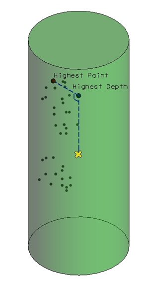
Each time AccuSnap snaps on a point, all points inside this cylinder are analyzed based on the method selected and the result is applied to move the cursor. The methods can be grouped in two categories, the ones which will change the 3D location of the points along the three axis (Highest Point and Lowest Point) and the ones that will affect only its depth along the direction (Highest Depth, Lowest Depth, Median Depth and Average Depth). The below illustration expresses this difference, the yellow cross represents the initial point snapped with AccuSnap and the green cylinder represents the search area centered on the initial point. In this case we simulate the usage of 2 methods: Highest Point (red point is found and returned) and Highest Depth (red point is found, project on the cylinder axis to compute the returned blue point). The same concept of reprojecting or not the result on the cylinder axis applies to other methods.